

By Lotte Govaerts
(This post was originally published on the Rogers Archaeology Lab blog on November 21, 2017. You can see the original post archived here.)
This is the third installment in a blog series on my recent trip to North Dakota. In previous entries I wrote about my visits to Fort Abraham Lincoln State Park, and the Lewis and Clark Interpretive Center. This entry is about a visit to Fort Clark Historic Site, on a particularly cold day.
Fort Clark State Historic Site encompasses 231.5 acres, approximately 15 miles southwest of Washburn, ND and 7.5 miles southeast of Stanton, ND. It includes the archaeological remains of Mih-tutta-hang-kush, a Mandan earth lodge village occupied between ca. 1822 and 1838, as well as an overlying Arikara village, occupied 1838 through 1861. The remains of a trade post called Fort Clark (1831–1860) and a competing post called Fort Primeau (1846–1861) are also included. A trail lined with interpretive signs loops around the site.

Because we visited during a full-on blizzard, we did not walk the whole trail. Snow cover also obscured the depressions in the ground where earth lodges once stood. However, because there are so many signs along the way, we still got to read a lot about the site’s history. It would have been fun to spend a little more time and walk the whole trail, but it really was VERY cold and windy. I’m not sure what the exact temperature was, but the next morning when we were getting ready to drive to our next destination, my friend Mat cheerfully informed me that the “real feel” temperature was -22°F (-30°C). Brrrrrr!

The Mandan village Mih-tutta-hang-kusch was established here around 1822. A trade post named Tilton’s Fort was constructed nearby in 1823 by the Columbia Fur Company (Wood et al. 2011, p. 48–49). In 1825 James Kipp built the predecessor to Fort Clark (referred to as “Fort Clark I” by researchers [ibid., p.55–58]), closer to the village. Fort Clark proper was established in 1830 by the Upper Missouri Outfit of the American Fur Company, and operated until 1860 (the Columbia Fur Company was bought out by the American Fur Company in 1827, becoming its Upper Missouri Outfit. In 1834, it was sold to Pratte, Chouteau & Company, later Pierre Chouteau, Jr. & Company). A competing trade post called Fort Primeau was established by Harvey, Primeau, and Company (also called the Union Fur Company) in 1846. It operated until 1861 (ibid., p. 192–193).
Mih-tutta-hang-kusch was hit by a smallpox epidemic in 1837, when a fur trade steamship carrying the virus docked at the fort. Approximately 90% of the inhabitants of the village were killed. Earlier epidemics had already reduced the Mandan in number (particularly the 1782 smallpox epidemic). Some estimates on the total number of Mandan survivors in 1837 are as low as 125 individuals (ibid., p. 165). These survivors moved north not long after. At this time, a group of Arikara moved to the site and built their lodges over top of the remains of the Mandan village. They remained there until 1861, when they also moved north.

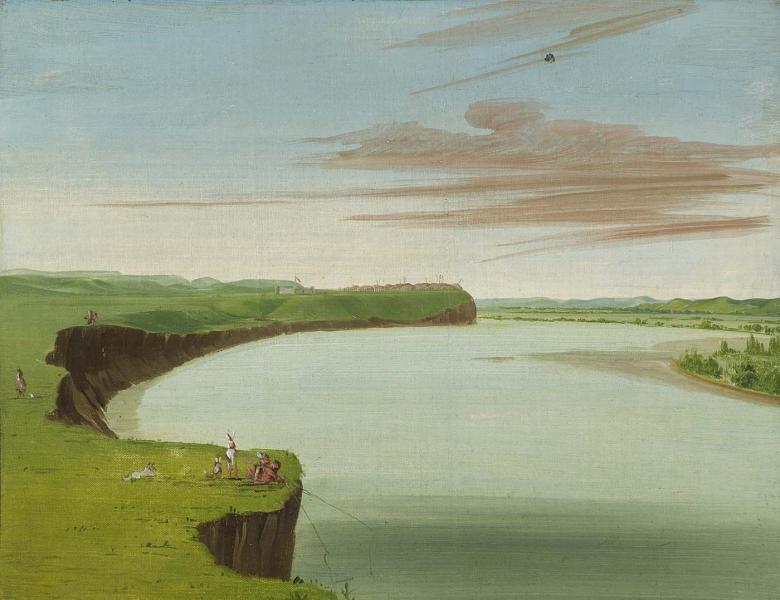
Well-known visitors to Fort Clark include George Catlin and Maximilian, Prince of Wied-Neuwied, accompanied by Karl Bodmer. Their paintings, drawings, and writings provide some details about life in the villages and trade posts. Additional information can be found in the journal written by Francis A. Chardon while he was in charge of Fort Clark between 1834 and 1839. Archaeological testing took place at the site intermittently between 1973 and 2001, adding archaeological data to researchers’ knowledge about the site.

In the next installment of this blog series, I will discuss our visit to Knife River Indian Villages National Historic Site. Stay tuned!
Bibliography/further reading
http://www.history.nd.gov/historicsites/clark/
Abel, Annie H., ed. 1932. Chardon’s Journal at Fort Clark, 1834-1839. Pierre: South Dakota State Department of History.
Thwaites, Reuben Gold, ed. 1906. “Travels in the Interior of North America, 1832-1834 by Alexander Philip Maximilian, Prince of Wied-Neuwied.” In Early Western Travels, 1748-1846, Vol. 22, 23, 24. Cleveland: Arthur H. Clark.
Wood, W. Raymond, W. F. Hunt, and Randy H. Williams. 2011. Fort Clark and Its Indian Neighbors: A Trading Post on the Upper Missouri. Norman: University of Oklahoma Press.

1 Comment
Add Yours →[…] Travels in North Dakota, Part III: Fort Clark State Historic Site […]