Travels in North Dakota, Part II: Lewis and Clark Interpretive Center and Fort Mandan

By Lotte Govaerts

(This post was originally published on the Rogers Archaeology Lab blog on November 14, 2017. You can see the original post archived here.)

This is the second post in a blog series on my recent trip to North Dakota. Check my previous post for photos from Fort Abraham Lincoln State Park. The second stop my friend Mat and I made on this trip was at the Lewis and Clark Interpretive Center in Washburn, North Dakota. It was snowing when we arrived there and the wind had picked up more, but the museum was open and we even got to tour the reconstructed Fort Mandan in the snow. Both are run by the Lewis and Clark Fort Mandan Foundation.

Scan of the full map. Rivers and mountain ridges are highlighted.
“A map of Lewis and Clark’s track, across the western portion of North America from the Mississippi to the Pacific Ocean: by order of the executive of the United States in 1804, 5 & 6.” (Image Source: Library of Congress G4126.S12 1814 .L4.)

Lewis and Clark Interpretive Center

After the United States acquired the Louisiana Territory in 1803, the government immediately set out to establish a presence in the area, explore, map, and attempt to find a river route to the Pacific. President Jefferson appointed Meriwether Lewis to lead an expedition into the new territory. He and William Clark, along with their “Corps of Discovery” traveled from St. Louis to the Pacific Ocean (at the mouth of the Columbia River) and back again, between May 14, 1804 and September 23, 1806.

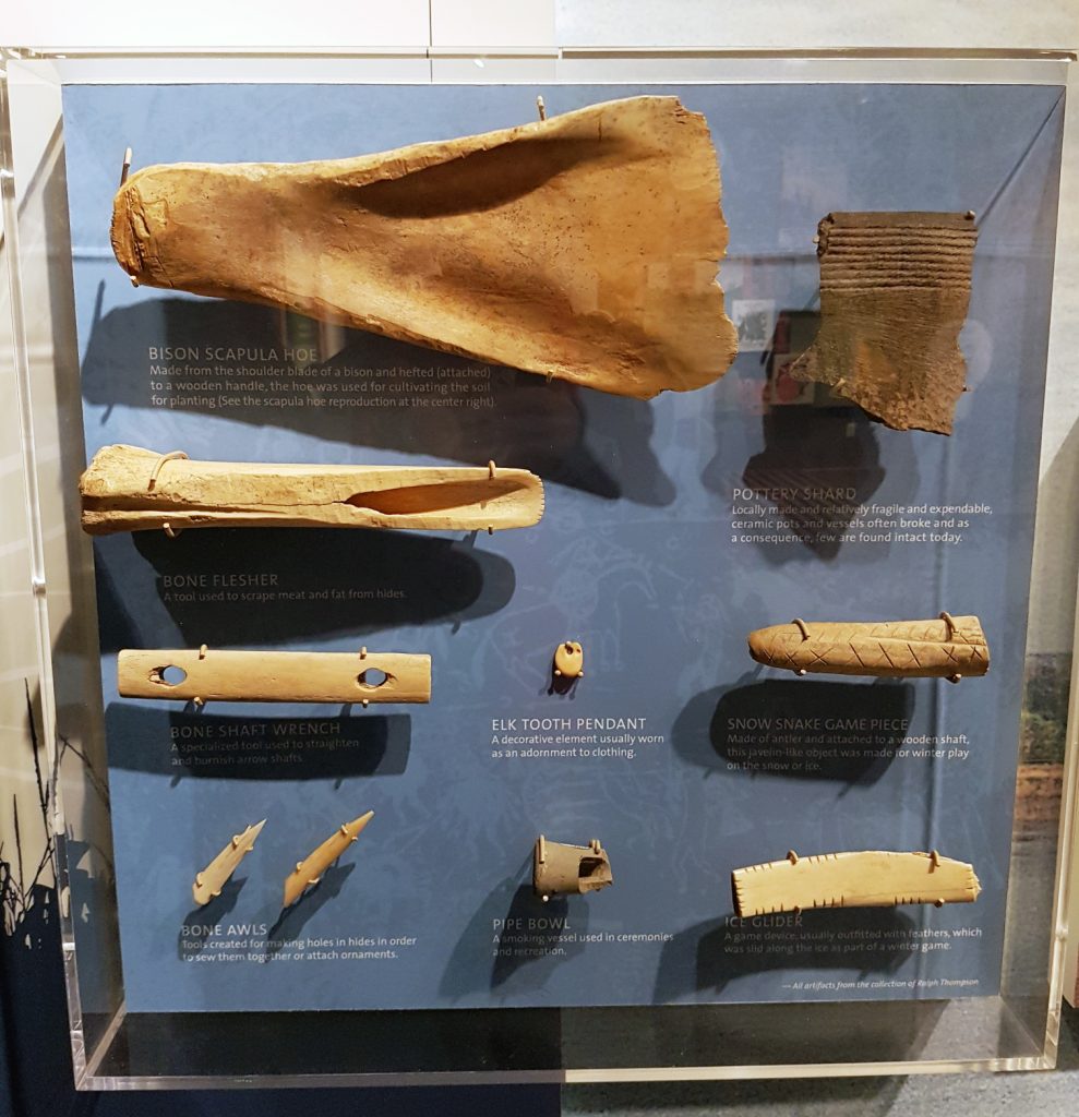
The Lewis and Clark Interpretive Center has exhibits illustrating different aspects of the Lewis and Clark expedition, as well as ones that illustrate local Native American and fur trade history. These exhibits include many archaeological artifacts, very similar to ones you may have seen in our various posts about our collections work.

Below are a few examples of exhibit cases at the Lewis and Clark Interpretive Center:

Straight-on view of bone and ceramic artifacts attached to a vertical display with text explanations. They include a bison scapula hoe, a bone flesher and shaft wrench, bone awls, a bone pendant and game piece, and ice glider, a pipe bowl, an elk tooth pendant, and a rim sherd.
Display of bone and ceramic artifacts at Lewis and Clark Interpretive Center (Photo Lotte Govaerts)
A display case with whole objects as well as partial objects. The larger whole objects have signs with explanations next to them. They include a metal kettle, a musket with some musket balls, and a trade axe. The lock for a flintlock also has a sign. Below those objects are bits of metal and broken tableware, at least one of which appears to be made into a game piece. There's also a few metal thimbles among the smaller objects at the bottom.
“Trade objects” display at Lewis and Clark Interpretive Center (Photo Lotte Govaerts)
The scapula hoe is attached to a wooden handle with a bunch of string. The wooden handles of other tools are also visible, but the tool parts of those are out of frame. These objects are all sitting on the floor in a corner, presumably to be used for educational activities.
A bison scapula hoe with wooden handle attached, sitting among other replica tools used for educational purposes. If you’ve been reading our River Basin Surveys collections posts, you might know that in archaeological contexts, we don’t normally find those with the wooden handles still attached, so our photos look a bit different. (Photo Lotte Govaerts)
A small room with shelves on the walls and a counter. Hanging on the walls are hats, scissors, axes, and strings of beads. On the shelves are folded pieces of cloth, string, bottles, and various other objects somewhat in the shadows. On the counter are bits of cloth with smaller objects spread out. THese iclude beads and possible jewelry, but it's hard to tell in this photo as that area is a bit washed out.
A reconstruction of what a trade room would have looked like, showing many of the items that were traded on the Upper Missouri in the 19th century. (Photo Lotte Govaerts)

Fort Mandan Reconstruction

Fort Mandan is the name of the fort Lewis and Clark (and the Corps of Discovery) constructed near the Mandan villages, where they stayed the winter of 1804–1805. The replica Fort Mandan (originally constructed by the McLean County Historical Society) is not in the exact location of the original Fort Mandan. That is because the site of the original Fort Mandan was never found. It is likely in/under the Missouri River now, as the river frequently shifted channels, and does not flow in the same place now as it did when the Corps of Discovery passed through.

Because of the uncharacteristically warm temperatures the area had seen in the days just before our arrival, ice and snow had melted inside the fort and then re-frozen. This made it impossible for the ranger who gave us the tour to open some of the doors and show us all the different rooms/exhibits, but we still got to see most of the fort. The blizzardy conditions seemed kind of appropriate for a winter fort visit.

A wintery scene, showing the fort, surrounded by pointy upright posts under a grey sky. Snow and ice surround it on all sides though a path to the entrance is mostly clear.
Approaching the reconstructed Fort Mandan in the snow. The weather gave us some appreciation of what life must have been like at Fort Mandan, though it wasn’t nearly as cold as the average temperature experienced during the winter of 1804-05! (see Burnette 2002 and Preston 2004 for information on weather conditions during the Lewis and Clark expedition)
Looking into the fort from the entrance gate. Low wooden buildings surround a vaguely triangular open court. The court is covered in ice and snow with odd mud patterns. Trees beyond the outer walls.
Looking into the interior of Fort Mandan. The odd patterns in the soil are frozen footprints. It had been unseasonably warm for a few days, and melting snow and ice had made the fort interior very muddy. By the time we visited, all the mud had frozen again, leaving these patterns, and leaving some of the doors in the fort frozen shut.
Inside view of a room made from wooden poles with daub or similar filling in the spaces between. The room has rough wooden beds and a desk with a stool. There's also shelves on the wall. The beds have skins and blankets on them. Uniforms are hanging on the wall and boots sit by the beds.
A reconstruction of Lewis and Clark’s room at Fort Mandan.” Image Source: Wikimedia Commons
Another room interior. Wood plank floor is visible here. This room has a lot of furs hanging on the walls and lying on the bed.
Inside the translator/fur trapper room. It was nicer than the enlisted men’s rooms, but not quite as nice as Lewis and Clark’s.

Stay tuned for the third part of this blog series, in which I describe a visit to Fort Clark Historic Site.

Bibliography & Further Reading:

Lewis and Clark Interpretive Center/Fort Mandan

Lewis and Clark Journals online at the University of Nebraska – Lincoln

Burnette, Dorian J. “Meteorological Reconstruction of the Lewis and Clark Expedition” Emporia State University, 2002.

Jackson, Donald. Thomas Jefferson & the Stony Mountains: Exploring the West from Monticello. Norman: University of Oklahoma Press, 1993.

Preston, Vernon. “The Journals of the Lewis and Clark Expedition 1803-1806: Weather, Water & Climate” Weather Forecast Office, Pocatello: NOAA National Weather Service, 2004.

Ronda, James P. Lewis and Clark among the Indians. Lincoln: University of Nebraska Press, 2002.

3 Comments

Add Yours →

Leave a Reply