

By Lotte Govaerts
(This post was originally published on the Rogers Archaeology Lab blog on October 26, 2023. You can see the original post archived here.)
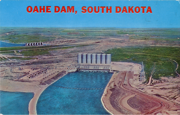
This post is part of a series on the historical archaeology of the River Basin Surveys and a sub-series on Oahe Dam. In the previous post in this series, I discussed the history of Oahe Dam and the impacts of dams in general. Before discussing the specific impacts of Oahe Dam on the people of Standing Rock and Cheyenne River reservations, I will first discuss the history of those reservations.
Both Standing Rock and Cheyenne River reservation were once part of the Great Sioux Reservation, which was created by the second Treaty of Fort Laramie. Just like the Fort Berthold Reservation we discussed previously, the boundaries of the Great Sioux Reservation changed over time.

The name “Sioux” comes from an Ottawa term that French visitors to the woodlands of the Mississippi valley wrote down as “Nadouessioux” (Ostler 2004, 21). The Sioux people refer to themselves as Oceti Sakowin, or the Seven Council Fires. This name does not refer to a political entity, but rather an identity based on a shared culture, language, and history. In the eighteenth century, pressure from moving populations to the east and dwindling food supplies caused some of the Sioux people to move west (the Lakota-speaking Teton and the Dakota-speaking Yankton and Yanktonai). This move is described as a return home, since the Sioux consider the Black Hills in what is now South Dakota the birthplace of their nation. At the time, other people (Cheyenne and Crow) were living in that region and were displaced by the Sioux. The Western Sioux acquired guns and horses through trading and became buffalo hunters. Especially after a series of smallpox epidemics significantly reduced the numbers of the more sedentary Missouri basin tribes in the late 18th century, the Western Sioux became a very powerful people.
During the early to mid-nineteenth century, tensions were growing between US populations/interests and the various Native peoples of the Northern Plains. The tribes continued to feel pressure from population shifts to the east, as well as encounters with overland travelers heading west and corporate interests intruding on their lands (e.g., steamboat crews cutting timber and fur traders). In an effort to reduce conflict, the United States decided to establish Native land rights. To create boundaries and obtain safe westward passage for US settlers and interests, the United States signed treaties with various Native peoples. In 1851, the US Commissioner of Indian Affairs organized a Grand Council with the Plains tribes, which resulted in the first Treaty of Fort Laramie.

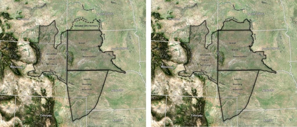
In the 1851 Treaty of Fort Laramie, the Sioux territory was described thusly: “The territory of the Sioux or Dahcotah Nation, commencing the mouth of the White Earth River, on the Missouri River; thence in a southwesterly direction to the forks of the Platte River; thence up to the north fork of the Platte River to a point known as Red Bute [sic], or where the road leaves the river; thence along the range of mountains known as the Black Hills, to the head-waters of Heart River; thence down Heart River to its mouth; and thence down the Missouri River to the place of beginning” (Kappler 1904, p. 594).
As Carl Sack (2017) explained, the vague description of the western boundary was interpreted in two different ways by the ICC in the 20th century.[1] Their 1965 interpretation located the boundary along “the drainage divide between the rivers flowing east into the Missouri and those flowing north into the Missouri” (15 ICC 577, cited in Sack 2017). The Sioux did not agree with this interpretation, because it left a neutral zone between their territory and that of the Crow to the west. Sioux attorneys argued this area belonged to them under the terms of the treaty. The ICC agreed with them in 1969 and redrew the boundary, based on Charles C. Royce’s 1896 Indian land cession maps.

After more conflict, the second Treaty of Fort Laramie was signed in 1868, between the United States and the different Sioux tribes (as well as the Arapaho). In this treaty, three different kinds of Sioux lands were described: The Great Sioux Reservation, hunting territory, and unceded land (the eastern Sioux reservations that were established earlier were not mentioned in this treaty).

This territory was described in Articles 2, 11, and 16:
Article 2: “…commencing on the east bank of the Missouri River where the forty-sixth parallel of north latitude crosses the same, thence along low-water mark down said east bank to a point opposite where the northern line of the State of Nebraska strikes the river, thence west across said river, and along the northern line of Nebraska to the one hundred and fourth degree of longitude west from Greenwich, thence north on said meridian to a point where the forty-sixth parallel of north latitude intercepts the same, thence due east along said parallel to the place of beginning; and in addition thereto, all existing reservations on the east bank of said river shall be, and the same is, set apart for the absolute and undisturbed use and occupation of the Indians herein named, and for such other friendly tribes or individual Indians as from time to time they may be willing, with the consent of the United States, to admit amongst them” (Kappler 1904, 998).
Article 11: “…reserve the right to hunt on any lands north of North Platte, and on the Republican Fork on the Smoky Hill River, so long as the buffalo may range thereon in such numbers as to justify the chase” (Kappler 1904, 1002).
Article 16: “The United States herby agrees and stipulates that the country north of the North Platte River and east of the summits of the Big Horn Mountains shall be held and considered to be unceded Indian territory, and also stipulates and agrees that no white person or persons shall be permitted to settle upon or occupy any portion of the same; or without the consent of the Indians first had and obtained, to pass through the same; and it is further agreed by the United States that within ninety days after the conclusion of peace with all the bands of the Sioux Nation, the military posts now established in the territory in this article named shall be abandoned, and that the road leading to them and by them to the settlements in the Territory of Montana shall be closed” (Kappler 1904, 1002, 1003).
The boundaries of these lands have also been interpreted in different ways over the years.
Many of the treaty’s articles focused on ways to impose a sedentary, agricultural lifestyle and mainstream American cultural norms on the Sioux people, in the form of annuities and provisions for agricultural work, blacksmith shops, clothes, schools, and mills. The Great Sioux Reservation included agencies for the different tribes; they were sometimes moved and renamed. The Sioux who agreed to settle on the reservation resisted the agricultural lifestyle and many left to hunt buffalo instead.
The US government already had its eye on the rich timber lands of the Black Hills when, in 1874, Custer’s expedition to the Black Hills found gold. The news of this find attracted gold seekers, leading to more conflict with the Sioux. After the Plains Wars that followed, in 1877 the US forced the Sioux to cede a 50-mile strip along the western border of the reservation, as well as all lands west of the Cheyenne and Belle Fourche rivers. This area included the Black Hills.
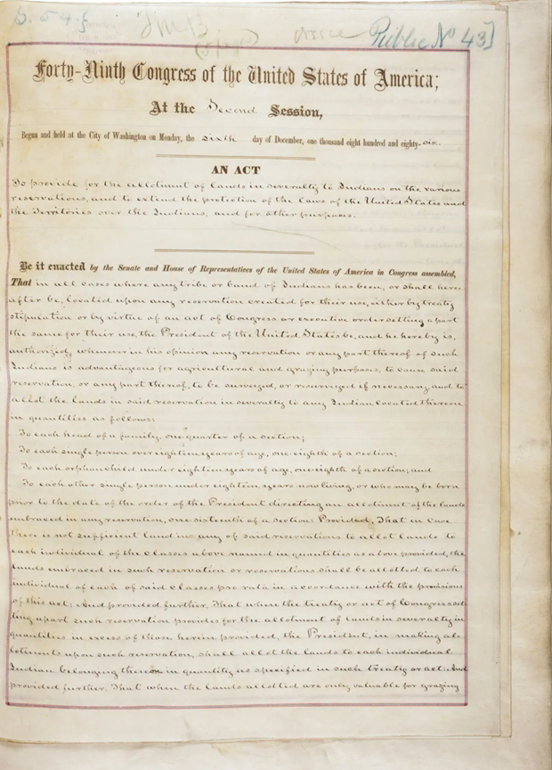
The General Allotment Act, or Dawes Act, was passed in 1887. Michael Lawson (2009, p. 30) described it as “the most devastating piece of legislation ever applied to the Sioux”. Under this law, Native American heads of households were given plots of land, to be held in trust by the government for 25 years. Upon receipt of the patent, the owners would receive full US citizenship. Unallotted lands were considered “surplus” and opened for sale to non-Natives. When the law was applied to the Sioux, lands were offered for sale before allotment was even completed. There were many other problems with the application of the law: The allotments on the Sioux reservation were not suitable for agriculture and not large enough for ranching. In addition, the Bureau of Indian Affairs did not provide the promised training or equipment. Native families were pressured to sell their land, checkerboarding the reservation. With each generation, these problems worsened as the lands were further split up.
The Sioux Act of 1889 officially broke up the Sioux Reservation, reducing the tribes’ lands by over 9,000,000 acres and creating the different, smaller reservations: Standing Rock, Cheyenne River, Lower Brule, Crow Creek, Pine Ridge, Rosebud, and Yankton Reservations. All of those were affected by the construction of the Pick–Sloan dams. We will examine the effects of Oahe Dam on the Cheyenne River and Standing Rock Reservations in the next posts in this series.
[1] The Indian Claims Commission was established under the Indian Claims Act of 1946 to investigate treaty claims. It had the power to interpret treaty boundaries and make decisions based on these interpretations.
References
Kappler, Charles J., ed. 1904. Indian Affairs: Laws and Treaties. Washington D.C.: Government Printing Office.
Lawson, Michael L. 2009. Dammed Indians Revisited: The Continuing History of the Pick-Sloan Plan and the Missouri River Sioux. Pierre: South Dakota State Historical Society Press.
Ostler, Jeffrey. 2004. The Plains Sioux and U.S. Colonialism from Lewis and Clark to Wounded Knee. Cambridge; New York: Cambridge University Press.
Sack, Carl. 2017. “Invisible Nation: Mapping Sioux Treaty Boundaries.” Northlandia (blog). February 18, 2017. https://northlandia.wordpress.com/2017/02/18/invisible-nation-mapping-sioux-treaty-boundaries/.
Previous posts in this series
What is Historical Archaeology?
How the River Basin Surveys Shaped Historical Archaeology
The Upper Missouri River Basin in the Nineteenth Century: Fur Trade
The Upper Missouri River Basin in the Nineteenth Century: Military Frontier
The Upper Missouri River Basin in the Nineteenth Century: Indian Agencies
Lake Sakakawea and the Woman it was Named After
Garrison Dam Archaeology: Village Sites
Garrison Dam Archaeology: 32MN1 – Fort Floyd
Garrison Dam Archaeology: 32ML2 – Like-A-Fishhook Village and Fort Berthold


