

By Lotte Govaerts
(This post was originally published on the Rogers Archaeology Lab blog on November 07, 2017. You can see the original post archived here.)
I have been working with collections from the Upper Missouri basin in North and South Dakota for about four years now, here at the National Museum of Natural History, but I had never actually visited the area until this past spring (late winter, really). My good friend and frequent travel companion Mat and I had the opportunity to take a short road trip across the area in early March of this year. Unfortunately, we arrived in North Dakota at the very end of an uncharacteristically warm period, which was followed by a blizzard. Our travel was impeded somewhat by these blizzard conditions which persisted throughout our visit.
Because of the time of year and the weather, many parks and other attractions were closed or inaccessible when we passed through the area. Despite this, we were still able to see a lot of the sights, and had a great trip. In this blog series, I want to share some pictures from that trip, as well as some historic photos and other related images.

One of the first places Mat and I visited in North Dakota was Fort Abraham Lincoln State Park, located about seven miles south of Mandan. The park does not close entirely for winter, but during the off-season, there are no interpretive services, no employees on site, and no exhibits, tours, or other activities. The visitor center is also closed.
On-A-Slant Village
One of the historic sites contained within Fort Abraham Lincoln State Park is On-A-Slant Village. On-A-Slant was a Mandan village occupied for approximately 200 years between the late 16th and 18th centuries. It was abandoned shortly after many of the village’s inhabitants were killed during the smallpox epidemic of 1781. The survivors moved north to the Knife River region. In the 1930s, five earth lodges were reconstructed on the site by Civilian Conservation Corps crews.

It was extremely cold when we visited, with an icy wind blowing. With no fire going, it wasn’t particularly warm inside these earth lodges, but we could appreciate how well-insulated they were, as the wind could not penetrate the walls at all.


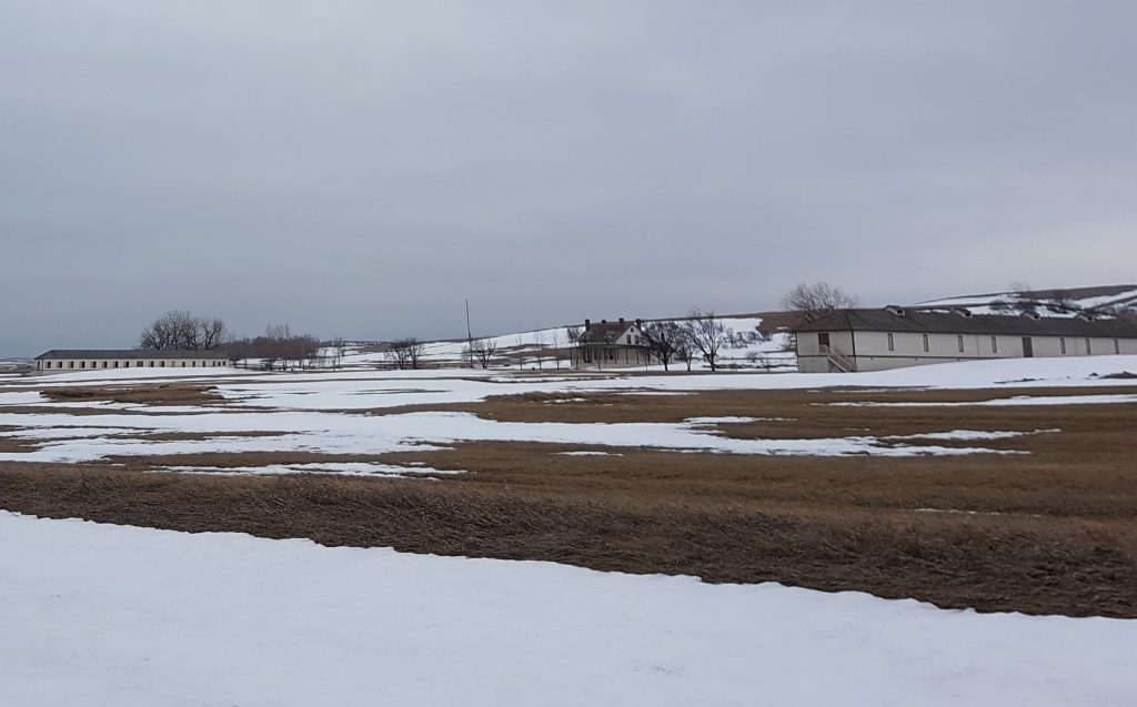
Fort Abraham Lincoln
Fort Abraham Lincoln State Park of course also includes the site of the fort it was named for.
Almost a century after the Mandan left the area, in June 1872, an infantry post named Fort McKeen was established in this location. It was soon renamed Fort Abraham Lincoln. A cavalry post was added the next year. Fort Abraham Lincoln housed three companies of the 6th and 17th Infantries and six companies of the 7th Cavalry, making it one of the largest military forts in the Northern Plains. It is perhaps most famous for being the home base from which the 7th Cavalry under Custer started out on the expedition that ended in their defeat at the Greasy Grass or Little Bighorn.
The house where George and Elizabeth Custer lived has been restored, along with the commissary storehouse, enlisted men’s barracks, a granary, and a stable. Visitors can take tours, but not during the winter season when we visited.

Quite a few historical drawings and photographs exist of Fort Abraham Lincoln and the Custer house in particular.


In the next post I will share photos from my visit to the Lewis and Clark Interpretive Center and the reconstructed Fort Mandan. Stay tuned!
Further reading:
Fort Abraham Lincoln State Park website
Chambers, Lee. Fort Abraham Lincoln, Dakota Territory. Atglen, PA: Schiffer Pub., 2008.
Fenn, Elizabeth A. Encounters at the Heart of the World: A History of the Mandan People. Macmillan, 2014.
Utley, Robert M. The Indian Frontier, 1846-1890. Rev. ed. Histories of the American Frontier Series. Albuquerque: University of New Mexico Press, 2003.

4 Comments
Add Yours →[…] Travels in North Dakota, Part I: Fort Abraham Lincoln State Park […]
[…] Travels in North Dakota, Part I: Fort Abraham Lincoln State Park […]
[…] Travels in North Dakota, Part I: Fort Abraham Lincoln State Park […]
[…] Travels in North Dakota, Part I: Fort Abraham Lincoln State Park […]