By Lotte Govaerts
(This post was originally published on the Rogers Archaeology Lab blog on April 17, 2024. You can see the original post archived here.)
This post is an installment in my series on the historical archaeology of the River Basin Surveys and my sub-series on the Oahe Dam. In my previous post, I discussed the impacts of the Oahe Dam on the Cheyenne River Reservation. In this one, I will focus on the impacts of that same dam on Standing Rock Reservation.
As I mentioned in my last post, the impacts of the Oahe Dam on the Sioux tribes have been studied extensively by Michael Lawson. He investigated the impacts of the Pick–Sloan dams on the Sioux tribes in his 1978 doctoral dissertation and published a paper dedicated to Standing Rock Reservation (Lawson 1976). His dissertation was converted into a book in 1982, which was updated in 2009 (Lawson 1982, 2009). Like my previous post, this one also is a very brief summary of the events and impacts described in those works; much more detail can be found in the cited research. In addition, to avoid too much repetition, I regularly refer to my previous post; I recommend reading both together so each post can provide additional context for the other.
Standing Rock Reservation before the Oahe Dam
As discussed previously, when the Great Sioux Reservation was created in 1868, the US government established several agencies across the reservation. It envisioned these agencies as part of a process of assimilation, in which Native peoples would abandon nomadic lifestyles and collective societies to farm individual plots of land instead. For the Lakota, however, the agency was the place where they picked up the supplies they were entitled to per the treaty.[1] The Grand River Agency was constructed in the northern part of the reservation, near the confluence of the Grand and Missouri Rivers, to serve mainly Sihasapa (Blackfeet), Hunkpapa, and Yanktonai bands. Many of the Lakota did not recognize the treaty and did not agree to live on the reservation; they continued roaming their unceded lands,[2] while the Yanktonai continued farming on the opposite side of the Missouri.

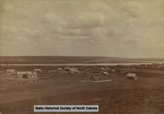
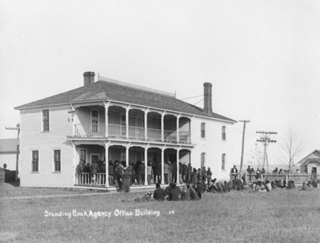
The land around the Grand River Agency was not well-suited for agriculture, so farming efforts were not particularly successful. In 1873, the US government decided to move the agency to a location it considered more convenient. The agent, Edmond Palmer, selected a site 75 river miles above Grand River, on a high table, where “the river [was] narrow and deep, with a good landing, … accessible to steamboats at all stages of water” and where there was “an abundance of cottonwood timber, suitable for building purposes, both above and below the agency, and a fine tract of land near by, sufficient to accommodate all the Indians for farming purposes” (United States Office of Indian Affairs, 1873, p. 598). This new location was, however, outside the boundaries of the Great Sioux Reservation proper, in the unceded territory just north of the reservation boundary. An Executive Order in 1875 extended the northern boundary to the Cannonball River in 1875 (Standing Rock Sioux Tribe 2022) so that the new boundaries included the agency, which was renamed Standing Rock not long after the move.
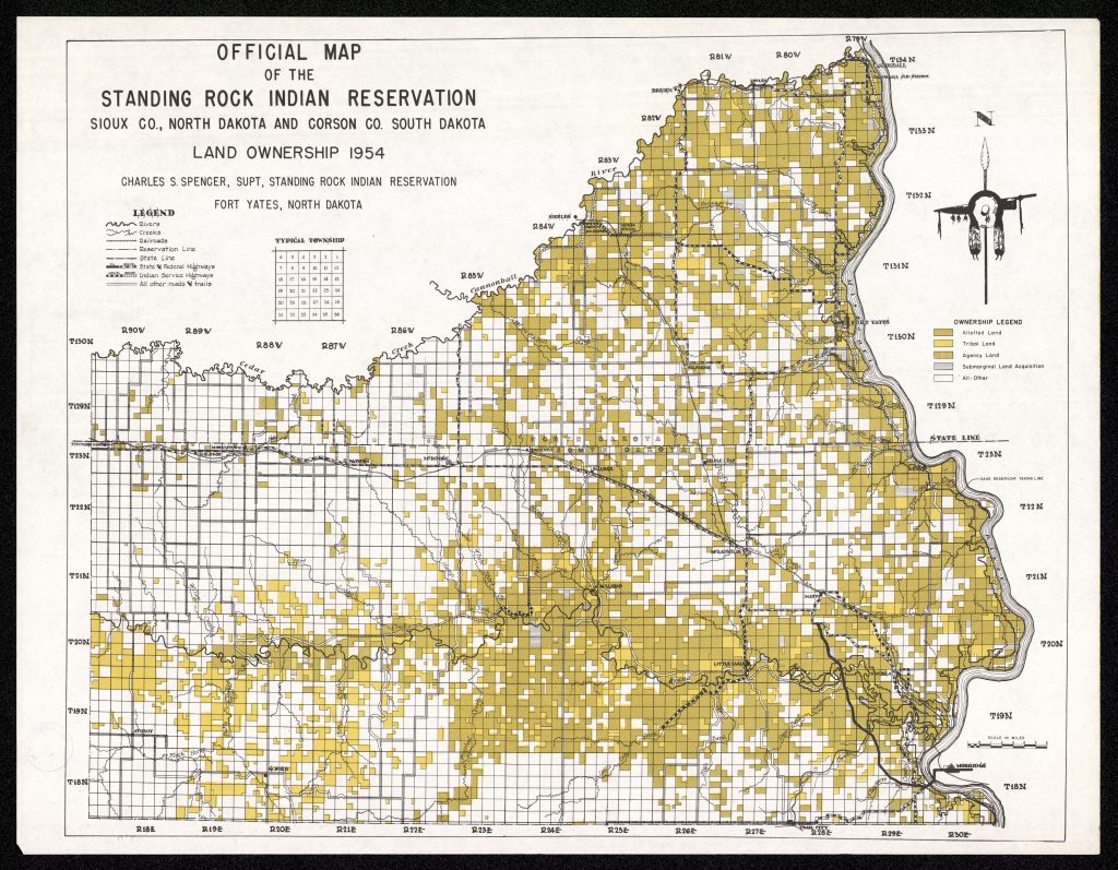
When the Great Sioux Reservation was broken up in 1889, the newly created Standing Rock Reservation included approximately 2.3 million acres. The states of North and South Dakota were created shortly after. The state line cut through Standing Rock Reservation, which continues to complicate jurisdictional issues on the reservation. Just like Cheyenne River Reservation, Standing Rock also lost territory in the years before Lake Oahe was filled, most notably due to allotment. When the Oahe Dam was constructed, Standing Rock Reservation encompassed approximately 1 million acres (Lawson 1976, p. 205).
Oahe Dam Negotiations
Negotiations between the government and Cheyenne River as well as Standing Rock Reservation were regulated via legislation enacted in 1950, following government negotiations with the Three Affiliated Tribes of Fort Berthold (Lawson 1976, p. 212–213; Lawson 2009, p. 93–95), as discussed in our previous post in this series.
Negotiations were off to a rough start when the tribe wanted to hire its own lawyer, completely independent from the Interior Department, rather than have the Bureau of Indian Affairs (BIA) pay for their legal services, as was standard procedure. The Indian Commissioner refused to sign off on this proposal. The tribe complained to the Interior Secretary, but their complaints were essentially ignored until a delegation, headed by chairperson Josephine Gates Kelly,[3] traveled to Washington DC and camped out at the Secretary’s office until they received a hearing. Eventually the Secretary overruled the Commissioner and approved the tribe’s legal representation contract (Lawson 2009, p. 97–98). This rough start set the tone for eight years of difficult negotiations, which included issues like more obstruction by the Commissioner and the untimely death of another Standing Rock chair, Whitney J. Agard, in 1952 (Lawson 2009, p. 107, 108).
One of the stipulations of the negotiation legislation was that the US Army Corps of Engineers (USACE) and the BIA prepare appraisals of the lands to be taken for the dam project. Like the USACE, the Standing Rock tribe also hired a private firm to prepare its own appraisal in 1951. It eventually arrived at a proposal for a cash settlement of $26.4 million ($2.8 million for the land, timber, improvements, and severance, $7.6 million for indirect/intangible losses, and $16 million for a rehabilitation program). This amount was intended to compensate the entire tribe, as not only individual landowners would suffer the disruption of the dam project. In addition, the tribe asked for mineral, grazing, and hunting rights, access to the reservoir, and a block of hydroelectric power for their exclusive use, at a low cost (Lawson 1976, 214–215; Lawson 2009, p. 127–128).
The USACE’s appraisal totaled only $1.32 million, and negotiators refused to budge. The BIA, whose appraisal was also lower than the tribe’s ($1.7 million) and the USACE both suggested that the rehabilitation program should be introduced in separate legislation (Lawson 1976, p. 215; Lawson 2009, p.).
As no agreement could be reached after many months of negotiating, the Standing Rock tribe took the matter directly to Congress in 1954. A bill was introduced, but because Congress was preoccupied with the Cheyenne River Reservation’s settlement at the time, the Standing Rock settlement was put on hold. A new bill was introduced after the Cheyenne River settlement was finalized in 1955 (Lawson 1976, p. 216; Lawson 2009, p. 126). Many hearings followed until in June 1956, the House Committee on Interior and Insular affairs recommended a cash settlement of $14,075,000. However, several committee members issued a dissenting opinion, which called the committee’s proposed amount “exorbitant” and suggested the final settlement should be decided in federal court and the rehabilitation program should be handled separately. This stirred up some controversy, which led Congress to stall on the Standing Rock legislation (Lawson 1976, p. 216–217; Lawson 2009, p. 128–129).
Yet another proposal was introduced in 1957, followed by more deliberation. Time was running out for the Standing Rock tribe, as the USACE had acquired almost all the land it needed to close the dam and fill the reservoir. In the spring of 1958, the USACE filed condemnation proceedings to obtain a tract of land it needed to relocate a section of highway and railroad. Six acres of the tract belonged to the Standing Rock Reservation. Despite treaty requirements, it had condemned lands belonging to Crow Creek, Lower Brule, and Yankton reservations for similar purposes not long before. The Standing Rock tribe sued to stop the USACE from continuing work on the Oahe project until a settlement was reached and to dismiss the condemnation suit based on their treaty rights.[4] The judge sided with the tribe and blocked the condemnation, but the dam project was allowed to continue (Lawson 1976, p. 217–218; Lawson 2009, p. 151–152).
A new bill made it through the House approximately two weeks before the public closing ceremony at the Oahe Dam in August 1958, and then through the Senate two weeks after the ceremony. Shortly after that, it was signed into law by President Eisenhower as Public Law 915. The total settlement amount in the bill, as signed into law, was $12,346,553: $1,952,040 for the land, $3,299,513 for direct and indirect severance damages, $6,960,000 for relocation and a rehabilitation program, and $135,000 for legal representation. The total amount was less than half of the tribe’s appraisal of its losses, but it was nonetheless the highest per-acre amount any of the tribes affected by Pick-Sloan received. The Standing Rock tribe also managed to secure all of the nonmonetary compensation it had asked for, aside from their request for hydroelectric power, which the US government decided would violate the Rural Electrification Act of 1936 (Lawson 1976, p. 217–219; Lawson 2009, p. 154–156).
Impacts of Oahe Dam
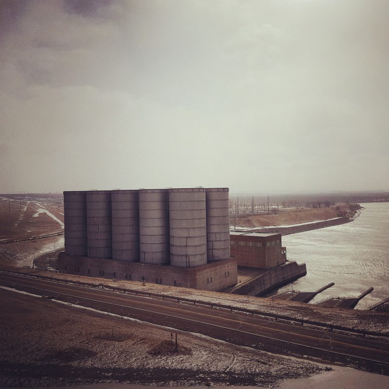
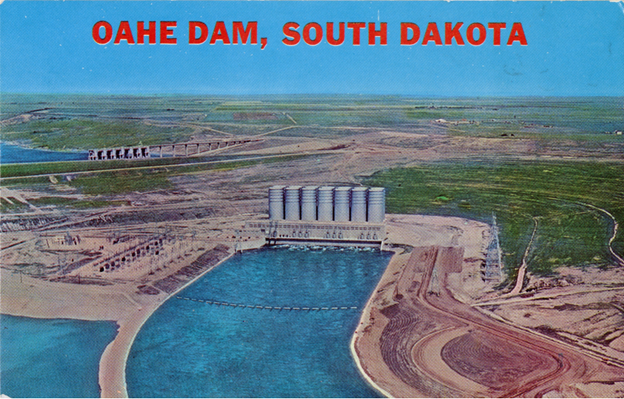
Oahe Dam inundated 55,994 acres of Standing Rock Reservation, mainly its most fertile and forested lands. Approximately 190 families (1/3 of the population) were forced to move from the most desirable homesites (Lawson 1976, p. 208; Lawson 2009, p. 48).
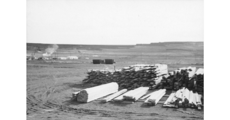
Ranching was the primary industry on Standing Rock Reservation and the dam destroyed 30,000 acres of the most valuable ranch land. Some 60% of the most successful ranches had to be relocated or liquidated. The reservation also lost most of its farmland. In addition, approximately 11,000 acres of woodland were flooded, representing 90% of the reservation’s timbered area. This was the reservation’s main source of lumber and the only source of fuel for more than half the population. The loss of these woods also reduced the natural food supply of the residents (Lawson 1976, p. 208–209).
Unlike at Fort Berthold and Cheyenne River Reservations, the Standing Rock Reservation’s headquarters at Fort Yates (ND) was not flooded; however, the town below the agency was, and most of the people living nearby had to be relocated. In addition, the agency site became separated from the mainland on an island (Lawson 1976, p. 209).
These losses naturally disrupted every single aspect of life on the reservation.
Because it took so long for the Standing Rock tribe to get its settlement finalized, the tribe faced a host of additional problems. Public Law 915 gave the USACE the responsibility of distributing the relocation funds. The USACE promised the tribe its funds soon after the settlement was finalized, but it took until January 1960 for the tribe to actually receive the money. The long wait caused an economic decline at the already depressed reservation. When the USACE provided the tribe with its settlement money, it also immediately evicted them, before any new housing could be prepared (Lawson 1976, p. 219–220; Lawson 2009, p. 181–182).
In addition, the tribe had won the right to salvage their timber, but the USACE stopped them from doing so, as they claimed these activities interfered with their own work. The court eventually sided with the tribe, but it took so long for the case to be decided that not enough time was left to salvage anything. The tribe thus lost out on this valuable lumber, and because the USACE did not salvage it either, it ended up creating a navigation hazard for many years (Lawson 1976, p. 220–221; Lawson 2009, p. 190).
Another drawn-out disagreement occurred over the issue of hiring workers to clear the reservation area. The USACE did not hire tribal members for this work; it claimed it was required to enter into contracts with the lowest bidder and could not dictate whom private contractors hired. The tribe again appealed to Congress. A bill was eventually introduced, in 1961, that would require the USACE to hire tribal members but was not considered before time had run out (Lawson 1976, p 221–222; Lawson 2009, p 184).
Negotiations for Additional Compensation
In the 1980s, renewed efforts to obtain additional compensation resulted in some success. The Garrison Diversion Unit Commission (GDUC) was established in 1984 to review the Garrison Diversion Unit, the irrigation and water supply project for the Garrison Dam. During a public hearing of the GDUC, tribal representatives of the Three Affiliated Tribes of Fort Berthold asked for the water development needs of the North Dakota tribes to be investigated, referring to the “institutional equity” clause that was included in the commission’s charter. The GDUC investigated the matter and found that Congress had failed to adequately compensate the tribes for their losses (Lawson 2009, p. 256–257).
Therefore, the Joint Tribal Advisory Committee (JTAC) was created in 1986 to carry out the GDUC directives (Lawson 2009, p. 258). The Interior Department was opposed to providing the tribes with additional compensation, arguing that the earlier settlements stipulated that they were final. The JTAC, on the other hand, believed that the government had a legal obligation to make the tribes “whole” for their losses (Lawson 2009, p. 258–259).

Witnesses testified about the impacts of the dams for two weeks. Economic consultants also provided estimates based on various analysis techniques. A “capitalization” technique was used to estimate the losses of the Three Tribes and concluded the amount was between 170 and 180 million in 1986 dollars (Lawson 2009, p. 259) while “consumer surplus” analysis arrived at an estimate of $342,897,374 for Standing Rock (Lawson 2009, p. 260).
JTAC thus concluded that Congress had not adequately compensated the tribes for the economic losses they sustained when the Garrison and Oahe Dams were constructed. It submitted its final report on May 23, 1986, recommending additional compensation in the range of $178.4 to 411.8 million for Fort Berthold and $181.2 to 349.9 million for Standing Rock, in addition to the implementation of various initiatives relating to development, water rights, and other issues (Lawson 2009, p. 260).
The Department of the Interior ignored these recommendations until the Senate Select Committee on Indian Affairs invited JTAC to present directly to that and several other committees. The federal government was coping with budgetary constraints at the time. No progress was made after multiple hearings until two things that coincidentally happened around the same time finally moved the matter along (Lawson 2009, p. 260–262). President Reagan, on a highly publicized visit to the Soviet Union made an off-the-cuff derogatory remark about the Indigenous population in the US. Both the remark and the angry responses from Native Americans were widely reported on internationally. To smooth things over, the President invited a group of tribal leaders to the White House, providing Ed Lone Fight of the Three Affiliated Tribes an opportunity to comment on the lack of progress. At the same time, a “double accounting” solution was proposed by a lobbyist to obtain funds for additional compensation: Congress was to build up a trust fund using surplus power revenues generated by Garrison Dam (Lawson 2009, p. 262–264).
More negotiations and recalculations followed without much progress, but eventually, a bill (H.R. 492) was attached to the Reclamation Projects Authorization and Adjustment Act of 1992 and passed both houses. The Three Affiliated Tribes of Fort Berthold and Standing Rock Sioux Tribe Equitable Compensation Act was signed into law (Lawson 2009, p. 264–266). It authorized a recovery trust fund capitalized at $149.2 million for the Fort Berthold tribes and $90.6 million for Standing Rock and authorized irrigation projects for the reservations. It also, as I mentioned in my previous post, took USACE lands that were not used for the dam projects and transferred them to the Department of the Interior. This legislation acknowledged for the first time that the government did not adequately compensate the tribes for their losses and set a precedent for other tribes (Lawson 2009, p. 266–267).
To Be Continued
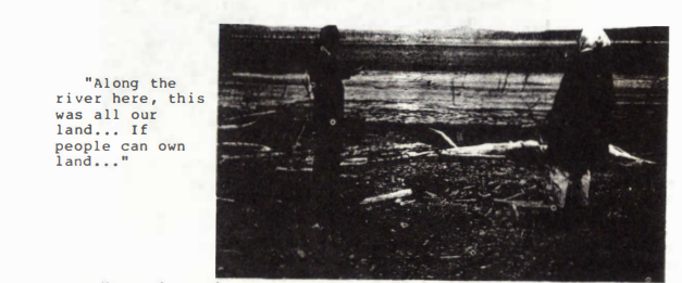
As we established in the previous post, the story of Oahe Dam’s impacts is an ongoing one. Much has changed since dam construction on the Upper Missouri started. Research on the environmental and social impacts of dams as well as their cost as compared to their benefits made them less popular in the decades after the Missouri River dams were built. In addition, the US government’s attitude toward tribal sovereignty moved away from ideas of termination in the 1960s and tribal governments became more powerful. Even so, echoes of the Oahe Dam story are obvious in the more recent Dakota Access Pipeline (DAPL) story. For example, the USACE rerouted the pipeline from its originally planned route near Bismarck to one closer to Standing Rock Reservation, for “environmental and economic reasons” (Estes 2017, p. 115). Changes in the federal government had a direct effect on the situation, as one administration ordered the easement for the pipeline on hold until a full environmental impact statement could be reviewed, while the next administration immediately reversed course (Estes 2017, p. 120). All of these events can be understood within the context of a long history of Indigenous resistance against settler colonialism (Estes 2017, 2019).

Challenges remain in terms of sovereignty and water rights, but the taking of land for the construction of large dams like Oahe Dam is less likely to be a problem in the future. The river restoration movement is growing across the country and around the world; dam removal is on the rise in the face of (aging) dam safety concerns and climate change. The largest-ever river restoration project is ongoing on the Klamath River in Oregon and California, where four dams are being removed. This project is the result of the efforts of Karuk, Yurok, Klamath, and other tribes (American Rivers 2023).
As for other hydropower projects, the Federal Energy Regulatory Commission recently announced a new policy, granting Native American tribes the power to quickly veto hydropower projects that impact tribal lands. The policy forces developers to consult with tribes before they can be granted a license to start construction (Phillis 2024).
This concludes my sub-series on the construction and impacts of the Oahe Dam. These last four posts provide context for my next posts, which will discuss the historical archaeology of the Oahe Reservoir area. This archaeological fieldwork took place in the midst of dam construction, negotiation, and relocation. The first of the Oahe Reservoir sites l will discuss here is Fort Manuel. Stay tuned!
[1] The Lakota referred to the agencies as “owakpamni oyake”, or distribution place (Ostler, 2004, p. 54)
[2] According to Andersson and Posthumus (2022, p. 131), the Fort Laramie Treaty divided the Lakota into Wágluȟe (Agency Indians) and Watȟógla (Free/Hunting Lakota), a division that deepened over time.
[3] Josephine Gates Kelly (1888–1976) was active in Indian politics for many years before she was elected tribal chair of Standing Rock Reservation in 1946 and became one of the first women to hold that position in the US (Lawson 2009, p. 96) In addition to her trip to Washington, DC to force a hearing, she again traveled there after the BIA, in the fall of 1951, announced its plans to consolidate the facilities for the Cheyenne River and Standing Rock Reservations. After much protest and lobbying, that plan was eventually abandoned (Lawson 2009, p. 99).
[4] According to the treaty, land could not be taken from the tribe without the approval of ¾ of its adult membership. However, the Supreme Court had previously ruled that Congress could abrogate treaties to exercise its sovereign right of eminent domain, as long as just compensation was provided. However, it had also ruled that only Congress had this power, and it could not be extended to federal agencies without congressional authorization (Lawson 1976, p. 217–218; Lawson 2009, p. 151–152).
References
American Rivers. 2023. “65 Dams Removed in 2022, Reconnecting 430 Upstream River Miles.” American Rivers (website). February 14, 2023. https://www.americanrivers.org/media-item/65-dams-removed-in-2022-reconnecting-430-upstream-river-miles/. Accessed March 4, 2024.
Andersson, Rani-Henrik, and David C. Posthumus. 2022. Lakhota: An Indigenous History. University of Oklahoma Press.
Estes, Nick. 2017. “Fighting for Our Lives: #NoDAPL in Historical Context.” Wicazo Sa Review 32 (2): 115–22.
———. 2019. Our History Is the Future: Standing Rock Versus the Dakota Access Pipeline, and the Long Tradition of Indigenous Resistance. Verso Books.
Klamath River Renewal Corporation. 2023. “Press Release | Removal of Diversion Dam Restores Flows to Klamath River Canyon for the First Time in Nearly a Century.” International Rivers (website). November 2, 2023. https://www.internationalrivers.org/news/press-release-removal-of-diversion-dam-restores-flows-to-klamath-river-canyon-for-the-first-time-in-nearly-a-century/.
Lawson, Michael L. 1976. “The Oahe Dam and the Standing Rock Sioux.” South Dakota History 6 (2): 203–29.
———. 1982. Dammed Indians: The Pick-Sloan Plan and the Missouri River Sioux, 1944-1980. Norman: University of Oklahoma Press.
———. 2009. Dammed Indians Revisited: The Continuing History of the Pick-Sloan Plan and the Missouri River Sioux. Pierre: South Dakota State Historical Society Press.
Ostler, Jeffrey. 2004. The Plains Sioux and U.S. Colonialism from Lewis and Clark to Wounded Knee. Cambridge; New York: Cambridge University Press.
Phillis, Michael. 2024. “Native American Tribes Gain New Authority to Stop Unwanted Hydropower Projects.” AP News (website). February 23, 2024. https://apnews.com/article/native-american-hydropower-climate-change-navajo-b5e86f47d52ca06bceecd782044264c1. Accessed March 4, 2024.
Standing Rock Sioux Tribe. 2022. “The Founding of Standing Rock Sioux Tribe.” Standing Rock Sioux Tribe (website). Updated 2022. https://www.standingrock.org/about/ Accessed March 04, 2024.
United States Congress Senate Select Committee on Indian Affairs. 1988. Final Report of the Garrison Unit Joint Tribal Advisory Committee: Hearing Before the Select Committee on Indian Affairs, United States Senate. November 19, 1987. Washington DC: US Government Printing Office.
Zambelich, Ariel, and Cassi Alexandra. 2016 “In Their Own Words: The ‘Water Protectors’ of Standing Rock.” NPR (website). December 11, 2016. https://www.npr.org/2016/12/11/505147166/in-their-own-words-the-water-protectors-of-standing-rock. Accessed March 4, 2024.
United States Office of Indian Affairs. 1873. Report of the Commissioner of Indians Affairs. Washington, D.C.
Previous posts in this series
What is Historical Archaeology?
How the River Basin Surveys Shaped Historical Archaeology
The Upper Missouri River Basin in the Nineteenth Century: Fur Trade
The Upper Missouri River Basin in the Nineteenth Century: Military Frontier
The Upper Missouri River Basin in the Nineteenth Century: Indian Agencies
Lake Sakakawea and the Woman it was Named After
Garrison Dam Archaeology: Village Sites
Garrison Dam Archaeology: 32MN1 – Fort Floyd
Garrison Dam Archaeology: 32ML2 – Like-A-Fishhook Village and Fort Berthold
Garrison Dam Archaeology: 32ML1 – Fort Stevenson