
By Lotte Govaerts
(This post was originally published on the Rogers Archaeology Lab blog on April 06, 2021. You can see the original post archived here.)
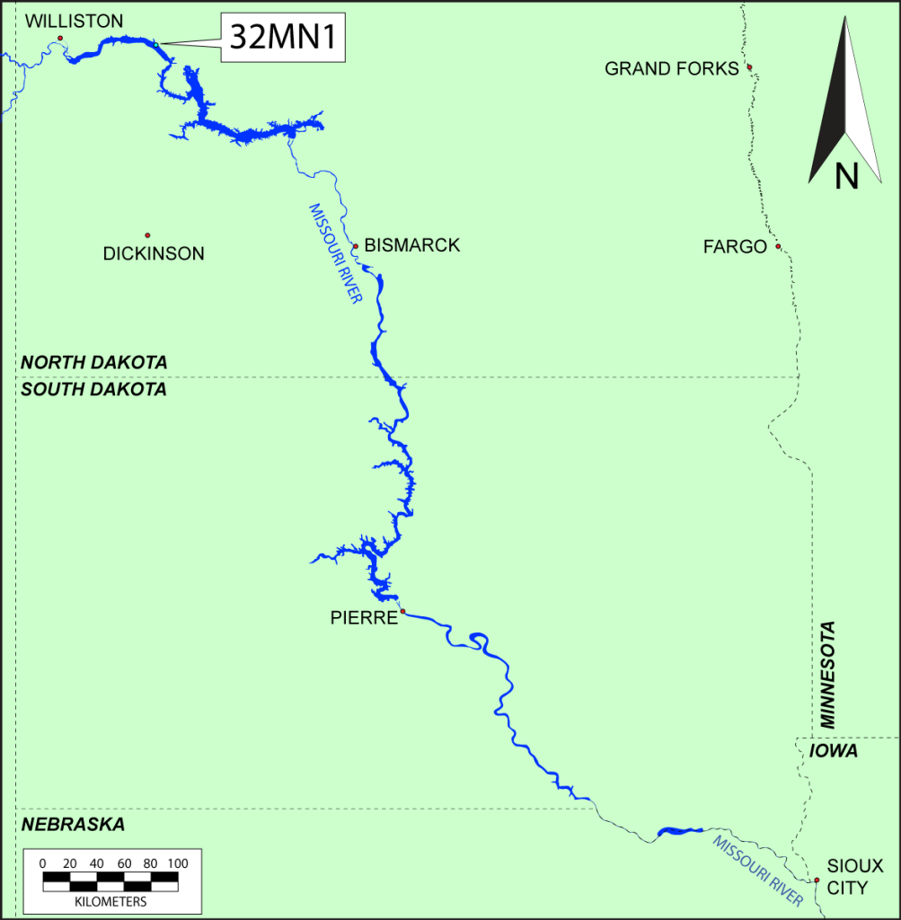
Today’s blog post is another installment in our series on the historical archaeology of the Missouri Basin Project. Links to all previous posts in this series are included below. In this post I examine the history and archaeology of site 32MN1, the site of an 1820s trading post called Fort Floyd. The site, now under the water of Lake Sakakawea, was located in Mountrail County, on a high terrace on the northern bank of the Missouri near its confluence with the White Earth River. The precise identification of the site has been somewhat problematic, as I will discuss in more detail below. The name Fort Floyd was not known at the time of its excavation.
Site History
The 1820s were an eventful time for the Missouri River trade. Two things happened in North America in the early 1820s that significantly changed the landscape for the fur trade. First, the Hudson’s Bay and Northwest companies merged in 1821, and the downsizing that followed that merger left many experienced fur traders out of business. Next, the U.S. government abolished the factory system in March 1822, leaving the Indian trade solely in the hands of private businesses. Some former Hudson’s Bay and North West Company employees were eager to do business as U.S. firms. Thus, Tilton and Dudley, also known as the Columbia Fur Company was created in St. Louis in 1822 (Woolworth and Wood 1960, p. 251; Wood and Casler 2015, p. 9). This new company immediately became a strong competitor to the dominant American Fur Company (AFC), focusing on the Mississippi and Missouri rivers in particular. John Jacob Astor, owner of the AFC, eventually managed to buy out the Columbia Fur Company in 1827. He turned it into the AFC’s “Upper Missouri Outfit” (UMO), largely maintaining the existing company structure on the Missouri River.

One of the former North West Company employees who moved to the Columbia Fur Company was James Kipp, who was not only an experienced fur trader, but also a master carpenter (Wood and Casler 2015, p. 8–10; Wood 2011). He constructed several forts on the Missouri River for the Columbia Fur Company, and later the UMO. In 1826, he constructed Fort Floyd at the mouth of the White Earth River, a location convenient for trade with the “Gens des Canots” band of Assiniboine who lived nearby, as well as other bands who frequented the area (Hunt 1994, p. 18). It was the westernmost outpost of the Columbia Fur Company at the time. When Fort Union, at the mouth of the Yellowstone, became operational in late 1828, Fort Floyd became less important to the company, and it was abandoned not much later, probably in 1830 (Woolworth and Wood 1960, p. 255; Wood and Casler 2015, p. 8, 19). Aside from the names of the people in charge of this post at various points in time, and two inventories dating to April 1829 (see below), not much is known about the fort from written sources.
Site Identification
![The map is blank ink on brownish paper with various colors drawn on to indicate routes and boundaries. Locations labeled on the map include Medicine Stone, "Here met the Yanktonans", Mandan Villages, (Corbeau) rows Inds Camp 17 June 1833, Ruins of Fort Mandan of Louis [sic] & Clarke, Fort Clark, Mih-tutta-hang-Kush, Ruphtare, Awatichai, Awachahwi, Elasha, and "Moenitarries Winter Village".](https://lottegovaerts.net/blog/wp-content/uploads/2026/02/MaximilianMap.png)
The confusion regarding the precise identification and name of site 32MN1 stems from some contradictory statements about the existence and location of Fort Floyd in the literature. Fur trade historian Hiram M. Chittenden, stated that Fort Floyd was an older name for the post that later became known as Fort Union (at the mouth of the Yellowstone) (Chittenden 1902, pp. 327–328). He based this identification on correspondence that was later lost. In their report of the excavation of 32MN1, Woolworth and Wood called the site “Kipp’s Post,” because they were aware that it was James Kipp who built the post, but did not yet know its proper name. They based their identification on Reuben Gold Thwaites’ translations of Prince Maximilian of Wied-Neuwied’s journals. Prince Maximilian was a German explorer, naturalist, and ethnologist who traveled extensively and published his journals. In the early 1830s he traveled up the Missouri River. He met James Kipp at Fort Clark when he stayed there in June of 1833, and learned about the former post at the White Earth River (Thwaites 1905, p. 228). Maximilian discusses the fort when the traveling party passed its former location, but the Thwaites edition did not include the post’s name (idem, p. 214). However, some years after the excavations at 32MN1 were completed, Joseph C. Porter was editing Maximilian’s original field journals and noticed that they did include the name of the post: “Fort Floyd stood several years ago at the place where we are now, where the present fur company had a post, which it abandoned.” Hunt (1994) based his Fort Floyd article on this new information, and explains that other contemporary records appear to confirm this location for Fort Floyd. He suggested that a mis-transcription in an AFC letter book is the cause of Chittenden’s differing point of view.
There is some confusion regarding the precise date of abandonment of the post as well. Maximilian stated that the fort was abandoned in 1929 (Thwaites 1905, p. 214), but a letter written at Fort Union and referencing Fort Floyd, quoted in Wood and Casler’s recent article (2015, p. 11), suggest a slightly later date, as the fort appears to have been occupied at least until May 1830.
Archaeology
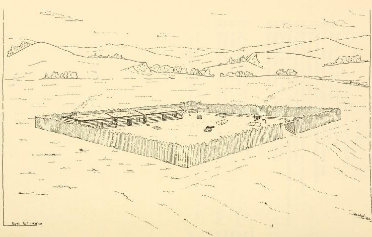
Site 32MN1 was known to locals before Thad C. Hecker mapped visible features in 1938. Hecker published a brief report on the site (Will and Hecker 1944, p. 84), but no effort was made to investigate it further until the large-scale archaeological work relating to the construction of Garrison Dam. In 1951, an RBS (River Basin Survey) field party under the direction of G. Hubert Smith carried out tests at the site. Although the area had been under cultivation for some years, several features (small hummocks and circular depressions) were visible at the surface. Cultivation had exposed some fired-clay chinking, bone, and a few (unspecified in the report) other artifacts. The crew located a palisade and collected artifacts. They drew a site map and took photos and notes. In July 1954, a crew from the State Historical Society of North Dakota returned to the site for more extensive excavations. They worked on the site through August of that year and excavated it fully (Woolworth and Wood 1960, pp. 255–256).
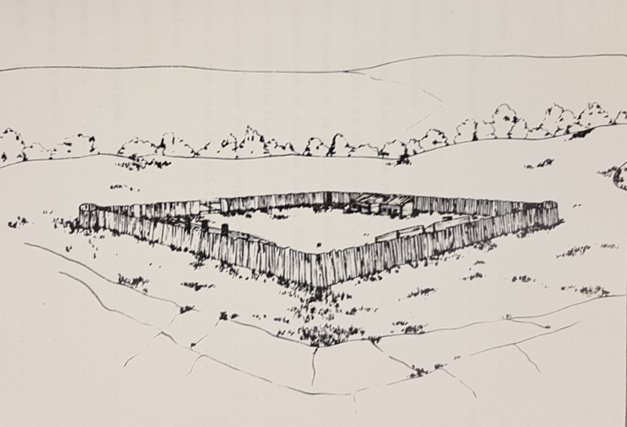
The site consists of a palisaded area approximately 96 feet or 29.3 meters square. The exact height of the palisade is unknown, but was probably around 15 feet (4.6 meters), similar the height of palisades at other forts of that era. There was what appears to have been a defensive bastion at the northeast corner, but not a corresponding one at the southwest corner, unlike what is commonly seen in these types of constructions. There was a ten foot (3 meters) gated entryway in the south wall.

Just inside the north wall of the palisades, facing the entrance, was a row of four structures, three of which were mud-chinked log constructions approximately 18 feet (5.5 meters) square. Only the westernmost of these structures appears to have been used as living quarters at the time the fort was abandoned, as it was the only building with a stick and mud fireplace. The remains of another fireplace were found under the floor of the building immediately east of the first one, suggesting it may have served as living quarters at some earlier point in time, before being turned into storage. A small number of window glass fragments recovered from the site suggests that at least one of these buildings had windows. The easternmost structure in the row appears to have been an 18×30 foot (5.5×9.1 meter) pole shed. There is some evidence of other lightly built structures inside the palisade (Woolworth and Wood 1960, pp. 256–262)

Because the post was deliberately abandoned it is likely that employees moved out everything that could be re-used elsewhere. Therefore any items left behind and preserved in the archaeological record were items that were broken, discarded, or lost while the post was occupied. There is some good information on 19th century trade post supplies in the literature, because of surviving inventories, trader journals, and letter books. There exists a single three-page inventory of trade goods in stock (along with an inventory of tools and equipment in use) for Fort Floyd, dated April 1829 (Wood and Casler 2015, p. 8). Some of the types of objects mentioned in the inventory were recovered during the archaeological excavation of 31MN2.
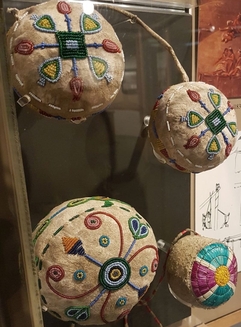
The most plentiful trade items found were glass beads. Excluding the approximately 5,000 blue beads that were found in a single infant burial, a total of 1,829 beads was recovered from the site.[1] This number likely represents only a fraction of the beads present at the site at the time of the excavation, because these beads are very small, and no soil was screened during this excavation. Other types of items that were traded in large volumes are not as easy to see in the archaeological record. Textiles are not as easily dropped or lost as tiny beads, and they degrade in archaeological contexts. Their presence on a site can be detected more indirectly, however. Lead bale seals were commonly used to “label” textiles in the 19th century and for hundreds of years before that. A single lead bale seal was cataloged at 32MN1 (Woolworth and Wood 1960, p. 303).

Some artifact types aren’t as easily divided into categories of “trade goods” or “daily life” items. Imported tools, for example, were traded, but also extensively used at the site. Similarly, personal items like buttons can be seen on the trade goods inventory, and were clearly traded at the post, but were also worn by people working at the post. Other personal items include tobacco pipes. A total of 200 pipe fragments were cataloged at 32MN1, 174 of them imported, 26 most likely locally produced shale and catlinite specimens.

The recovery of a single doll part, as well as an infant burial indicates the presence of children. Because the manner of burial differs from common local practice, the child appears to have had a non-Native parent (Wood and Casler 2015, p. 6). From the literature, we know that trade post employees regularly married local women and had children with them. These wives and children lived at the post alongside their husbands and single men. Another indicator of the presence of Native people and of women in particular is the presence of small charcoal-filled pits for smoke-tanning hides, chipped stone scrapers, and fleshing tools, which are all associated with dressing hides, a task usually carried out by women.
The rest of the artifact assemblage is largely made up of architectural items (mainly iron nails and chinking fragments) and kitchen/table-related artifacts like broken tableware and kitchen refuse in the form of animal bone.
In my dissertation I compare the artifact assemblage from Fort Floyd with the assemblages from five other trading post sites, as I will explain in upcoming installments in this series. Next up, however, is a more in-depth look at the history and archaeology of the sites of Fort Berthold and Fort Stevenson, also located in the Garrison dam survey area.
[1] This number, as well as all other artifact count numbers in this post are from my dissertation research. For the purpose of artifact assemblage comparison between sites, I counted up artifact totals using original RBS catalogs along with current collection inventories, and in some cases, manual item counts in collections. The artifact collection for Fort Floyd resides with the State Historical Society of North Dakota (SHSND), and I received a lot of help counting these particular artifacts from Dr. Wendi Field Murray along with interns and volunteers at the SHSND.
References
Chittenden, Hiram M. The American Fur Trade of the Far West. 3 vols. New York: Francis P. Harper, 1902.
Hunt, William J. “Fort Floyd: History and Archaeology of an Enigmatic 19th Century Trading Post.” North Dakota History 61, no. 3 (1994): 7–20.
Thwaites, Reuben Gold, ed. “Travels in the Interior of North America in the Years 1832, 1833, and 1834.” In Early Western Travels 1748-1846, Vol. 23. Cleveland: Arthur P. Clark, 1905.
Will, George F, and Thad C Hecker. “The Upper Missouri River Valley Aboriginal Culture in North Dakota.” North Dakota Historical Quarterly 11, no. Jan.-April (1944): 5–126.
Wood, W. Raymond. “James Kipp: Upper Missouri River Fur Trader and Missouri Farmer.” North Dakota History 77, no. 1–2 (2011): 2–35.
Wood, W. Raymond, and Michael M. Casler. “A Revised History of Fort Floyd, North Dakota.” North Dakota History 80, no. 4 (2015): 3–13.
Woolworth, Alan R., and W. Raymond Wood. “The Archaeology of a Small Trading Post (Kipp’s Post, 31MN1) in the Garrison Reservoir, North Dakota.” In River Basin Survey Papers 15 – 20, Vol. 176. Bureau of American Ethnology Bulletin, 1960.
Previous posts in this series:
What is Historical Archaeology?
How the River Basin Surveys Shaped Historical Archaeology
The Upper Missouri River Basin in the Nineteenth Century: Fur Trade
The Upper Missouri River Basin in the Nineteenth Century: Military Frontier
The Upper Missouri River Basin in the Nineteenth Century: Indian Agencies
